![](/images/other/stat-length.png)
![Randonnée A pied Brentino Belluno - Belluno Veronese - Passo del Cerbiolo - Photo](https://media.geolcdn.com/t/1900/400/4e8f8a13-b5f2-473b-88b2-776320ec8c7e.jpeg&format=pjpeg&maxdim=2)
Belluno Veronese - Passo del Cerbiolo
SityTrail - itinéraires balisés pédestres
Tous les sentiers balisés d’Europe GUIDE+
![Longueur](/images/other/stat-length.png)
![Altitude max](https://static1.geolcdn.com/siteimages/upload/files/1508320355ic_sort_altitude_max_24dp.png)
![Dénivelé positif](https://static1.geolcdn.com/siteimages/upload/files/1508320355ic_sort_den_pos_24dp.png)
![Km-Effort](/images/other/stat-length.png)
![Altitude min](https://static1.geolcdn.com/siteimages/upload/files/1508320355ic_sort_altitude_min_24dp.png)
![Dénivelé négatif](https://static1.geolcdn.com/siteimages/upload/files/1508320355ic_sort_den_neg_24dp.png)
![Boucle](https://static1.geolcdn.com/siteimages/upload/files/16400158638029165_repeat_loop_refresh_sync_direction_icon.png)
![A pied](https://static1.geolcdn.com/sitytour/trail-icons/100.png)
4h06
Difficulté : Facile
![Scannez ce code QR pour ouvrir la randonnée dans l'application SityTrail](https://capi.geolives.com/qq0zvz2zws4bq2lad0pu/sitytour/trails/3116870/qr.png?size=200)
Application GPS de randonnée GRATUITE
À propos
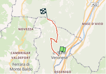
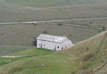
Randonnée A pied de 5,6 km à découvrir à Vénétie, Verona, Brentino Belluno. Cette randonnée est proposée par SityTrail - itinéraires balisés pédestres.
Description
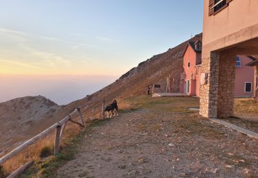
Randonnée créée par Club Alpino Italiano Sezione di San Pietro in Cariano.
relation mantained by Club Alpino Italiano Sezione di San Pietro in Cariano, before making changes contact the CAI structure
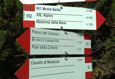
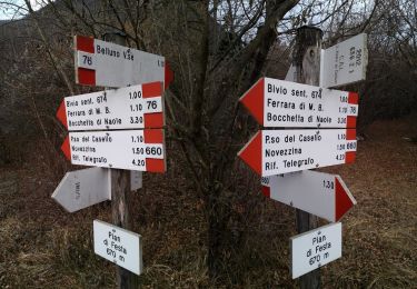
Symbole: 678 on white red flag
Site web: http://www.caivalpolicella.it
Localisation
Commentaires
Randonnées à proximité
![Randonnée A pied Dolcè - Dorsale Media della Lessinia - Photo](https://media.geolcdn.com/t/375/260/afc7e6a9-be91-497d-bf8b-d4a1a7cdc50b.jpeg&format=jpg&maxdim=2)
![A pied A pied](https://static1.geolcdn.com/sitytour/trail-icons/100.png)
A pied
![](/images/other/stat-length.png)
![](https://static1.geolcdn.com/siteimages/upload/files/16400158638029165_repeat_loop_refresh_sync_direction_icon.png)
![Randonnée A pied Dolcè - Peri - Genderli - Photo](https://media.geolcdn.com/t/375/260/777353f4-ff94-483e-9d9b-dfe477a2a7ec.jpeg&format=jpg&maxdim=2)
![A pied A pied](https://static1.geolcdn.com/sitytour/trail-icons/100.png)
A pied
![](/images/other/stat-length.png)
![](https://static1.geolcdn.com/siteimages/upload/files/16400158638029165_repeat_loop_refresh_sync_direction_icon.png)
![Randonnée A pied Sant'Anna d'Alfaedo - Dorsale Alta della Lessinia - 4° tratto - Sentiero di Rocca Pia - Photo](https://media.geolcdn.com/t/375/260/a8c0a9df-6f17-4400-a005-59d56ad0f479.jpeg&format=jpg&maxdim=2)
![A pied A pied](https://static1.geolcdn.com/sitytour/trail-icons/100.png)
A pied
![](/images/other/stat-length.png)
![](https://static1.geolcdn.com/siteimages/upload/files/16400158638029165_repeat_loop_refresh_sync_direction_icon.png)
![Randonnée A pied Dolcè - Dorsale Alta della Lessinia - Photo](https://media.geolcdn.com/t/375/260/83a31790-dc1e-4af9-b4ba-530f507478c5.jpeg&format=jpg&maxdim=2)
![A pied A pied](https://static1.geolcdn.com/sitytour/trail-icons/100.png)
A pied
![](/images/other/stat-length.png)
![](https://static1.geolcdn.com/siteimages/upload/files/16400158638029165_repeat_loop_refresh_sync_direction_icon.png)
![Randonnée A pied Sant'Anna d'Alfaedo - Dorsale Alta della Lessinia sezione Passo Fittanze - Tommasi - Photo](https://media.geolcdn.com/t/375/260/b1092593-b5b7-4abe-b57e-c7a3af9fcea8.jpeg&format=jpg&maxdim=2)
![A pied A pied](https://static1.geolcdn.com/sitytour/trail-icons/100.png)
A pied
![](/images/other/stat-length.png)
![](https://static1.geolcdn.com/siteimages/upload/files/16400158638029165_repeat_loop_refresh_sync_direction_icon.png)
![Randonnée A pied Avio - Sentiero Bovi - Photo](https://media.geolcdn.com/t/375/260/4702fb67-6073-457f-bd90-e77faeb3b6e8.jpeg&format=jpg&maxdim=2)
![A pied A pied](https://static1.geolcdn.com/sitytour/trail-icons/100.png)
A pied
![](/images/other/stat-length.png)
![](https://static1.geolcdn.com/siteimages/upload/files/16400158638029165_repeat_loop_refresh_sync_direction_icon.png)
![Randonnée A pied Ferrara di Monte Baldo - Sentiero Agostino Goiran - Photo](https://media.geolcdn.com/t/375/260/22e59220-543c-460c-85bc-686efa3a6b75.jpeg&format=jpg&maxdim=2)
![A pied A pied](https://static1.geolcdn.com/sitytour/trail-icons/100.png)
A pied
![](/images/other/stat-length.png)
![](https://static1.geolcdn.com/siteimages/upload/files/16400158638029165_repeat_loop_refresh_sync_direction_icon.png)
![Randonnée A pied Ferrara di Monte Baldo - Belluno Veronese - Ferrara di Monte Baldo - Photo](https://media.geolcdn.com/t/375/260/df35d1f2-ff15-446a-a202-4932293f3539.jpeg&format=jpg&maxdim=2)
![A pied A pied](https://static1.geolcdn.com/sitytour/trail-icons/100.png)
A pied
![](/images/other/stat-length.png)
![](https://static1.geolcdn.com/siteimages/upload/files/16400158638029165_repeat_loop_refresh_sync_direction_icon.png)
![Randonnée A pied Sant'Anna d'Alfaedo - Tommasi - Corno d'Aquilio - Photo](https://media.geolcdn.com/t/375/260/33839697-309b-4a41-a6be-57c145ca1bcd.jpeg&format=jpg&maxdim=2)
![A pied A pied](https://static1.geolcdn.com/sitytour/trail-icons/100.png)
A pied
![](/images/other/stat-length.png)
![](https://static1.geolcdn.com/siteimages/upload/files/16400158638029165_repeat_loop_refresh_sync_direction_icon.png)